
Stage 11 Portencross to Largs
Download the digital map (GPX file) for this section
Portencross Castle – Three Sisters – Hunterston Nuclear Power Station – Hunterston Sands – Gull’s Walk – A78 Cycle Path – Fairlie Shore Path – Fairlie Church – A78(T) pavements – Cycle Path – Largs Yacht Haven
Distance: 11.5 km = 7.2 miles Time: 3.5 hours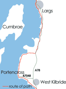
Walking summary: Easy – farm tracks, pavements, paths, cycle tracks.
We strongly advise purchase of the Guide Book for a detailed description and map of the route.
Plus OS Explorer Map 341.
Car Parks: Portencross Car Park – Largs Yacht Haven public car park.
Transport: Train service from Largs to Ayr and Glasgow. Good bus service. Ferry to Great Cumbrae.
Historical: Portencross hill fort and dun. Portencross Castle and Spanish Galleon. The Hawking Craig. Hunterston Castle. Southannan House. Fairlie Castle. Fife of Fairlie Yachts. Kelburn Castle.
General: Portencross harbours. The Three Sisters. Hunterston Nuclear Power Stations. Hunterston Construction Yard. Clyde Port Deepwater Terminal. Largs Yacht Haven.
Nature: Birds of prey, shore and sea birds. Coastal geology. Natural woodlands. Waders and ducks on Hunterston Flats.
Eating/Provisions: Fairlie shops. Largs Yacht Haven.
Public Toilets: Burnfoot Picnic Park, Fairlie (Automatic all year 24 hours).
Accommodation: List of Accommodation, Fairlie Picnic Park. See the accommodation section for more information.